Courtesy of the Cooperative Institute for Research in the Atmosphere
Storm Éowyn turned out to be the most powerful named storm by far in the UKUKThe United Kingdom of Great Britain and Northern Ireland, commonly known as the United Kingdom (UK) or Britain, is a country in Europe, off the north-western coast of the continental mainland. It comprises England, Scotland, Wales and Northern Ireland. and Ireland using my Gale Index method. It finished top in both the gale hours and the maximum gust hours category, but finished third behind Isha and Ciara on peak hourly GIGIGale Index. There were a number of missing observations from key stations such as Belmullet, Mace Head and Glasgow, who knows the GI could have been even higher if these observations hadn’t gone missing, possibly as a result of power cuts brought about by the storm itself.
09 UTCUTCCoordinated Universal Time or UTC is the primary time standard by which the world regulates clocks and time. It is within about 1 second of mean solar time (such as UT1) at 0° longitude (at the IERS Reference Meridian as the currently used prime meridian) and is not adjusted for daylight saving time. It is effectively a successor to Greenwich Mean Time (GMT). 24 Jan 2025Gale Index – 24 January 2025Maximum gusts 240000-250600 UTCHours of storm force gusts or higherHours of gale force 8 or higher
6 Dec 2024 12 UTCUTCCoordinated Universal Time or UTC is the primary time standard by which the world regulates clocks and time. It is within about 1 second of mean solar time (such as UT1) at 0° longitude (at the IERS Reference Meridian as the currently used prime meridian) and is not adjusted for daylight saving time. It is effectively a successor to Greenwich Mean Time (GMT). Surface analysis MSLPMSLPMean sea level pressure is the pressure at sea level, or, when measured at a given elevation on land, the station pressure reduced to sea level assuming an isothermal layer at the station temperature. falling 10.4 hPahPaA Hectopascal is the SI unit of pressure and identical to the Millibar in the last 3 hrs at Belmullet (1), with dewpoints of 11°C coming into Valentia (2).
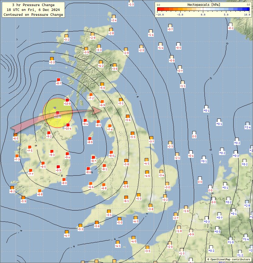
6 Dec 2024 13 UTC 3 hr Pressure Tendencies The central pressure of Storm Darragh may not be explosive cyclogenetic, but 3 hr pressure falls of 12 hPa across W Ireland at present are not to be sniffed at. 🤨 The Belmullet barograph is showing a roller coaster ride 😉
6 Dec 2024 15 UTC Surface analysis Dewpoints of 13°C into SW Ireland. Cold front getting close to Valentia Big pressure fall across Ireland of 10 hPa or more over 3 hrs. Weather buoy K2 goes offline – can you beleive it! No double structures here!!
6 Dec 2024 18 UTC 3 hr pressure changes
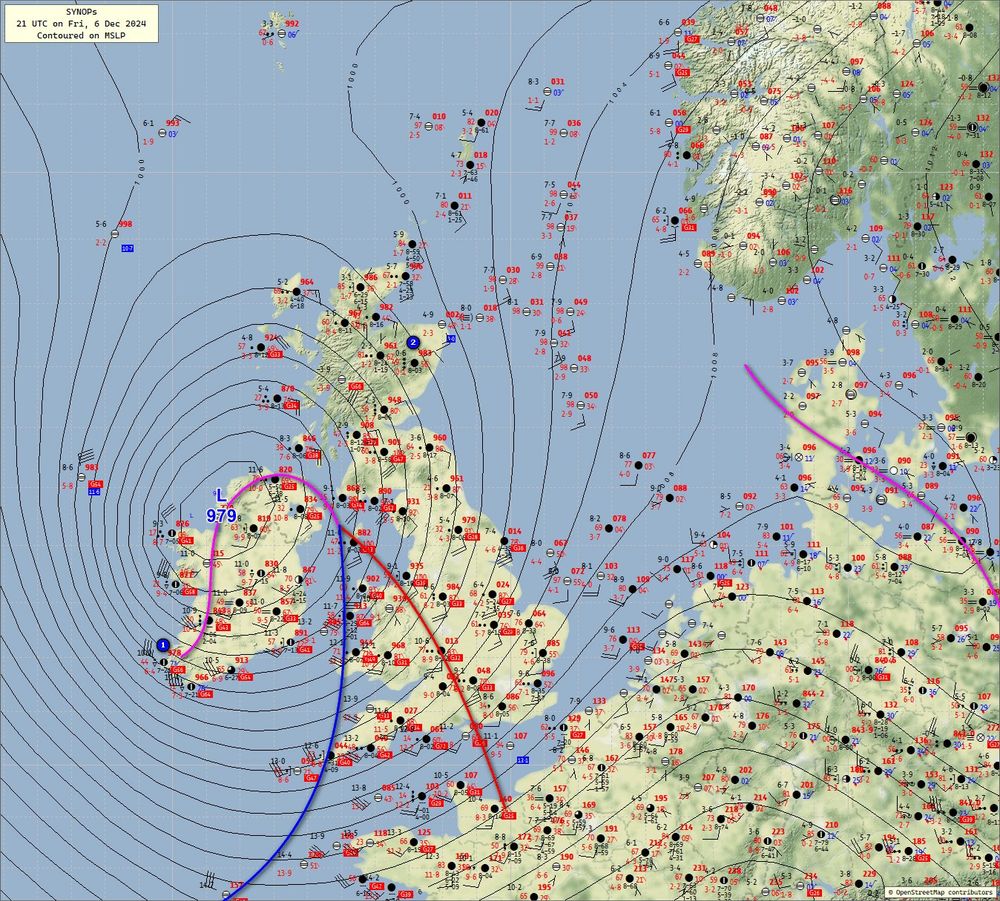
6 Dec 2024 21 UTC Surface analysis Big pressure rises at Valentia (1) First signs of very strong northerly to the W of Ireland Sleet at Aboyne (2)
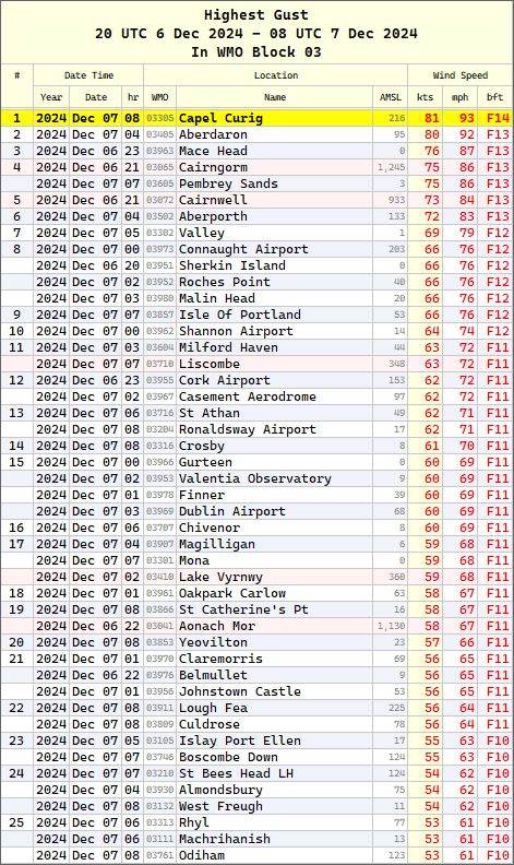
7 Dec 2024 08 UTC Highest overnight gusts It looks like Capel Curig, aka as the Snowdonia wind tunnel, has recorded the highest gust of 81 kts or 93 mph overnight.
7 Dec 2024 09 UTC Total Precipitation [33 hrs] Estimates from weather radar A wet night in many places away from the far SE, with areas of 40-50 mm over high ground of Argyll & Bute, N Ireland, Lake district & Snowdonia,with white pixels indicating >80 mm in wettest places.
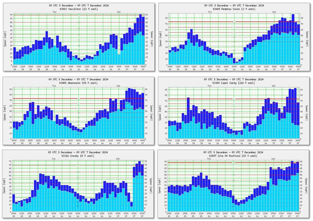
7 Dec 2024 09 UTC A selection of anemographs Notice the high gust-mean ratio at Capel Curig. The rapid increase of speed at Crosby at 06 UTC. Inland gale at Yeovilton.
7 Dec 2024 03-14 UTC Total Precipitation [11 hrs] Estimates from weather radar. The heaviest of the rain in Wales seems to have been further W than the AMBER warning area so far, with >80 mm over Snowdonia.
7 Dec 2024 16 UTC Aberporth Still blowing a force 10 NW’ly with gusts of 85 mph. Gale force 8 for 24 straight hours. 😱 That’s where the BBCBBCThe British Broadcasting Corporation (BBC) is the national broadcaster of the United Kingdom, based at Broadcasting House in London. It is the world's oldest national broadcaster, and the largest broadcaster in the world by number of employees, employing over 22,000 staff in total, of whom approximately 19,000 are in public-sector broadcasting. & ITV should have sent their film crews today 😉
7 Dec 2024 19 UTC Max Gusts [mph] You can hear the wind moaning in the bell tower at Notre-Dame… The bells, the bells…
7 Dec 2024 19 UTC 24 hr MSLP difference The pressure is close to 47 hPa higher at Belmullet than it was last night.
Was there a gust of 96 mph or not at Berry head? The original tweet from the UKMOUKMOThe Meteorological Office is the United Kingdom's national weather service. It is an executive agency and trading fund of the Department for Business, Energy and Industrial Strategy has just vanished.
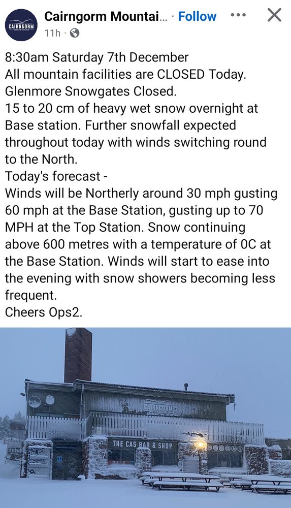
Snow on CairngormCairn GormCairn Gorm (Scottish Gaelic: An Càrn Gorm) is a mountain in the Scottish Highlands. It is part of the Cairngorms range and wider Grampian Mountains. With a summit elevation of 1,245 m (4,085 ft) above sea level, Cairn Gorm is classed as a Munro and is the seventh-highest mountain in the British Isles..
00 UTCUTCCoordinated Universal Time or UTC is the primary time standard by which the world regulates clocks and time. It is within about 1 second of mean solar time (such as UT1) at 0° longitude (at the IERS Reference Meridian as the currently used prime meridian) and is not adjusted for daylight saving time. It is effectively a successor to Greenwich Mean Time (GMT). 16 Oct 198706 UTC 16 Oct 1987
Only three hourly Synops I’m afraid, and many of them missing from the worst affected regions. At a glance, and from this limited SYNOPSYNOPSYNOP (surface synoptic observations) is a numerical code (called FM-12 by WMO) used for reporting weather observations made by manned and automated weather stations. SYNOP reports are typically mad hourly and consist of groups of numbers (and slashes where data is not available) describing general weather information, such as the temperature, barometric pressure and visibility at a weather station. data, although it looked a pretty windy night, you wouldn’t have thought it had been as severe as it was across the southeast of England. I’ve no idea if my hind sight analysis was anywhere close to the analysis on the day. I was an observer at Kinloss at the time, and missed all the excitement after being posted to Scotland that summer.
Here are some random images, tables and animations that I posted regarding Storm Lilian to my Twitter account @xmetman. Nothing particularly devastating about the winds or the rain from the storm itself, which the Met OfficeUKMOThe Meteorological Office is the United Kingdom's national weather service. It is an executive agency and trading fund of the Department for Business, Energy and Industrial Strategy should really have never named. It was gone in a flash, and although there were gusts in excess of 70 mph on the Lancashire coast, only eight SYNOPSYNOPSYNOP (surface synoptic observations) is a numerical code (called FM-12 by WMO) used for reporting weather observations made by manned and automated weather stations. SYNOP reports are typically mad hourly and consist of groups of numbers (and slashes where data is not available) describing general weather information, such as the temperature, barometric pressure and visibility at a weather station. stations recorded a gale. Gale Index wise the storm didn’t register above the 200 mark because of its size, with the extratropical cyclone that had been Hurricane Ernesto scoring much higher earlier in the week. I should have written a piece about Ernesto, but when you have so few followers as I have, I thought what’s the point 😪
I’ve developed yet another Windows weather application, one that I have been meaning to write for several years now, it analyses reported hourly wind speed and gusts in SYNOPSYNOPSYNOP (surface synoptic observations) is a numerical code (called FM-12 by WMO) used for reporting weather observations made by manned and automated weather stations. SYNOP reports are typically mad hourly and consist of groups of numbers (and slashes where data is not available) describing general weather information, such as the temperature, barometric pressure and visibility at a weather station. observations from WMOWMOThe World Meteorological Organisation is a specialized agency of the United Nations responsible for promoting international cooperation on atmospheric science, climatology, hydrology and geophysics. block #03, and produces a simple daily and hourly gale index [GIGIGale Index] for all available stations below 250M, which usually ends up being around 150 sites across the UKUKThe United Kingdom of Great Britain and Northern Ireland, commonly known as the United Kingdom (UK) or Britain, is a country in Europe, off the north-western coast of the continental mainland. It comprises England, Scotland, Wales and Northern Ireland. and Ireland. I’ve done it to see how viable it would be for an organisation, such as the UKMOUKMOThe Meteorological Office is the United Kingdom's national weather service. It is an executive agency and trading fund of the Department for Business, Energy and Industrial Strategy, to come up with an objective, rather than a subjective way of naming storms. The screenshot above shows a data grid of hourly GI in the main form, with daily and hourly data from the 26th of September up to the 21st of December 2023. I have now analysed all hourly SYNOP data back to 2015, which is the year naming storms commenced in the UK.
The GI itself is very simple, and is just the sum of the mean Beaufort force for each station plus half the Beaufort force of it’s highest gust, from all stations for that hour. I’ve found that from looking at all previous named storms that an index of 100 equates to a gale and 200 to a named storm event. You can see the seven named storms we’ve seen since the start of the 2023/24 season. Using these values as a guide I can easily list all the named storms. Some of these were named other Met Services other than the UKMO, and a couple of the storms were named for their heavy rain rather that strong winds.
This is where the fun starts, because as you can see Pia, a storm named by the DMIDMIThe Danish Meteorological Institute is the national meteorological service for Denmark and Greenland. on the 21st of December, had a maximum hourly GI of 709 which is at least twice as high as any of the previous named storm so far this season. It was eventually named, but surprisingly not by the UKMO. If you look down the table you’ll also notice storm Ciaran only had a GI of 169, and using the 200 threshold for storms as a guide it should not have been named. There are plenty more named storms like Ciaran that just didn’t make the grade. There are also other times when a GI exceeded 200 but that didn’t result in a storm being named. On looking back I’ve found that this often occurs when a low affects Scotland, and I beleive it’s because the UKMO link the naming of storms with their NSWWSNSWWSThe National Severe Weather Warning Service is a service provided by the Met Office in the United Kingdom. The purpose of this service is to warn the public and emergency responders of severe or hazardous weather which has the potential to cause danger to life or widespread disruption. This allows emergency responders to put plans into place to help protect the public and also allowing the public to make necessary preparations.. Usually, but not always, if they issue an amber warning a storm automatically gets named, sometimes a yellow warning is all that’s required outside Scotland, but because the threshold for an amber strong wind warning is 80 mph (or higher) rather than 70 mph for elsewhere in the UK, amber warnings are rarer in Scotland. That’s the reason why I believe the UKMO didn’t choose to name Pia. The next logical step is to break down the GI regionally because that’s it weakness. Below is a ranked list of all the named storms since 2015 and all the missed events. As you can see I have also assigned each named storn a category from one to five. Ciara, a category five storm, had the highest maximum GI of any of them. In third place you’ll notice is the Ross-shire (or the unnamed) storm of January 2015 which I’ve included because it occurred just before the naming of storm commenced.
This application is still WIPWIPWork In Progress so ignore the mean column for now I will get round to fixing it.
Meteorological Autumn 2023 has seen some quite varied weather types, predominantly anticyclonic until mid October and then full on cyclonic. It also contained four named storms, some of which were more deserving than others for being named. I can’t even remember them all, only Ciaran and Debi stick out. Zonality also did a couple of about faces during October and again towards the end of November.
Not so much an item as a Twitter dump of stories, charts, graphs and images from tweets I wrote concerning Storm Babet. Not sorted out too well chronologically either. I’ll try to do better next time. Maybe I’ll stick with the blog and just upload links to Twitter from now on?
20 Oct 2023 12 UTCUTCCoordinated Universal Time or UTC is the primary time standard by which the world regulates clocks and time. It is within about 1 second of mean solar time (such as UT1) at 0° longitude (at the IERS Reference Meridian as the currently used prime meridian) and is not adjusted for daylight saving time. It is effectively a successor to Greenwich Mean Time (GMT). Temperatures & Anomalies Rather cold in the NENENorth East, much milder further south. Not a single mention of temperatures for today on the BBCBBCThe British Broadcasting Corporation (BBC) is the national broadcaster of the United Kingdom, based at Broadcasting House in London. It is the world's oldest national broadcaster, and the largest broadcaster in the world by number of employees, employing over 22,000 staff in total, of whom approximately 19,000 are in public-sector broadcasting. too caught up on listing the number of flood warnings21 Oct 2023 08 UTC Surface analysis Something like that20 Oct 2023 13 UTC Surface analysis19 Oct 2023 11 UTC Surface analysis18-20 Oct 2023 Anemograph Inverbervie is a notoriously windy place, but the E’ly gale that’s been running there for the last 31 hours must rank as one of the windiest spells the AWSAWSAutomatic Weather Station there has ever recorded18-20 Oct 2023 48 hr totals Estimated rainfall totals from weather radar I’ve used the lower colours to make things a bit clearer over the wider UKUKThe United Kingdom of Great Britain and Northern Ireland, commonly known as the United Kingdom (UK) or Britain, is a country in Europe, off the north-western coast of the continental mainland. It comprises England, Scotland, Wales and Northern Ireland..20 Oct 2023 14 UTC A surprisingly dry and bright day with sunny intervals here in StrathpefferStrathpefferStrathpeffer (Scottish Gaelic: Srath Pheofhair) is a village and spa town in Easter Ross, Highland, Scotland, with a population of 1,469. after yesterday’s afternoon rain, although it feels cold in the strong easterly wind.21 Oct 2023 Flooding on the A834 Strathpeffer to Dingwall road close to Castle Leod21 Oct 2023 00-16 UTC Estimated accumulations from weather radar The heavy rain has finally stopped after almost 13 hours. Quite remarkable accuracy with estimate of 43.1 mm for Strathpeffer, Vantage Pro reports 43.4 mm Goodbye BabetOctober 2023 Strathpeffer Three large rainfall events 6-8 Oct the storm that never was 87.6 mm 48hr 19 Oct storm Babet 32.6 mm in 16 hr 21 Oct 29.2 mm in 9 hr so far 192.4 mmStrathpeffer totals 00-00 rather than the 09-09 totals from Dingwall, nevertheless still much wetter 5 miles further westThe average for October here is 102mm, so we are already close to 200% with still another 9 days to go15-22 Oct 2023 Inverbervie Anemograph19-22 Oct 2023 Mean Speed Average hourly [kts] A 33 kt mean speed is not bad going for 72 hours at Inverbervie.18-20 Oct 2023 CairngormCairn GormCairn Gorm (Scottish Gaelic: An Càrn Gorm) is a mountain in the Scottish Highlands. It is part of the Cairngorms range and wider Grampian Mountains. With a summit elevation of 1,245 m (4,085 ft) above sea level, Cairn Gorm is classed as a Munro and is the seventh-highest mountain in the British Isles. Last 48 hrs The wind has moderated slightly this morning but still blowing force 12 from SE’E. Temperatures now sub-zero and wind chill close to -12°C so it’s either white or has a very icy glaze up there at the moment21 Oct 2023 14 UTC Glenshee Snow above 2500 ft today now clearing from southeast.19 Oct 2023 20 UTC Amazing rain shadow cast by Cairngorms persists across Nairn & Forres. Kinloss 0.4 mm [06-18] Lossiemouth 0.8 mm [06-18]19-20 Oct 2023 02 UTC Estimates from radar Had to change to high colour range contouring Purple pixels indicating wettest areas have seen >175mm in last 20 hrs across E Scotland, and close to the city of Aberdeen itself. 32.4mm in 14 hrs in Strathpeffer19 Oct 2023 06-20 UTC Rainfall totals from weather radar estimates More white pixels appearing across E Grampians indicating totals of >80mm since 06 UTC. Ben Wyvis has some too as well. 17.4 mm since 13 UTC here in Strathpeffer in heavy rain.19 Oct 2023 1510 UTC Here’s a pseudo hyetograph for a spot close to the Bridge of Dee gleaned from 5 minute weather radar imagery. Estimates of 41.6 mm so far today.
00 UTCUTCCoordinated Universal Time or UTC is the primary time standard by which the world regulates clocks and time. It is within about 1 second of mean solar time (such as UT1) at 0° longitude (at the IERS Reference Meridian as the currently used prime meridian) and is not adjusted for daylight saving time. It is effectively a successor to Greenwich Mean Time (GMT). – 24 Dec 2016
On 20 UTC on the 23 December 2016, instrumental wave heights reported by the automatic weather buoy [MAWS] K5 out in the North Atlantic at 59.1° north and 11.7° west were as high as 15.4 metres or just over 50 feet. Wave heights have since dropped to around 30 feet, before increasing again tomorrow as storm Conor passed close by to the north. Looking at the midnight chart I should imagine waves may have been considerably higher than this a little further north judging by the strength of the gradient. Sadly, since I wrote the original article the UKMOUKMOThe Meteorological Office is the United Kingdom's national weather service. It is an executive agency and trading fund of the Department for Business, Energy and Industrial Strategy now suppress wave height data in their hourly weather buoy observations, so much for progress.
Hourly wave heights from K5Plotted observations from K5
Another Meteo FranceMeteo FranceMétéo-France is the official service of meteorology and climatology in France. named storm, Patricia, the center of which ran fairly and squarely across the UKUKThe United Kingdom of Great Britain and Northern Ireland, commonly known as the United Kingdom (UK) or Britain, is a country in Europe, off the north-western coast of the continental mainland. It comprises England, Scotland, Wales and Northern Ireland. during Wednesday. Gusts of 40 to 50 knots are good going for early August across northern France, and I notice one as high as 56 knots at Meaulte to the NENENorth East of Paris. The main feature wasn’t the wind across the UK so much but the heavy rain, particularly across the North and East of Yorkshire.
After bringing storm force winds overnight to the Netherlands here’s a loop of satellite images showing Storm Poly, as it’s now been called by DWD, exiting stage right. So NMI don’t name it even though it brought storm force winds and gusts of 80 knots but the DWD do? What a crazy system. It could only happen in Europe. It’s been reported that the next name on the DWD list is going to be Storm Roly.
I see there’s talk about how this winter has seen no named storms issued by the UKMOUKMOThe Meteorological Office is the United Kingdom's national weather service. It is an executive agency and trading fund of the Department for Business, Energy and Industrial Strategy and it’s friends. That’s because the naming of storms is a subjective based system based on impact based warnings system, at least in the UKUKThe United Kingdom of Great Britain and Northern Ireland, commonly known as the United Kingdom (UK) or Britain, is a country in Europe, off the north-western coast of the continental mainland. It comprises England, Scotland, Wales and Northern Ireland.. True, it has been a quieter winter than average, especially in the first half of December, but that doesnt mean there’s been a shortage of candidates for named storms, but because nearly all only affected the north of Scotland and require the issuance of an amber warning, i.e. gusts of 90 mph or more, this didn’t happen. If the UKMO wanted, it could easily create an objective system based on regional NWPNWPNumerical weather prediction uses mathematical models of the atmosphere and oceans to predict the weather based on current weather conditions. data, then I think then, people might take it more seriously.
06 UTCUTCCoordinated Universal Time or UTC is the primary time standard by which the world regulates clocks and time. It is within about 1 second of mean solar time (such as UT1) at 0° longitude (at the IERS Reference Meridian as the currently used prime meridian) and is not adjusted for daylight saving time. It is effectively a successor to Greenwich Mean Time (GMT). Analysis
Storm Otto was named by the DMIDMIThe Danish Meteorological Institute is the national meteorological service for Denmark and Greenland. because the UKMOUKMOThe Meteorological Office is the United Kingdom's national weather service. It is an executive agency and trading fund of the Department for Business, Energy and Industrial Strategy refused to issue an amber warning for strong winds for Scotland on Wednesday (15th). That left the way open for the DMI to step in and claim the storm as their own, despite the strength of the wind across Denmark in the afternoon being no stronger than it was in the early morning across the north and east of Scotland or northeast England. I have no idea what’s going on down at Exeter, but they certainly seem to have it fixed in their heads that amber warnings will only be issued for Scotland if wind speed exceed 90 mph, and because amber warnings trigger the naming of storms, that, and persistent high pressure in the south, is the reason why there’s been a paucity of them this autumn and winter across the UKUKThe United Kingdom of Great Britain and Northern Ireland, commonly known as the United Kingdom (UK) or Britain, is a country in Europe, off the north-western coast of the continental mainland. It comprises England, Scotland, Wales and Northern Ireland..
I’m sure that there should have been at least one named storm across IONAIONAIslands Of North Atlantic.
Yes I know there's an island called Iona, but this is so I don't have to use the term 'British Isles' when referring to the whole of Ireland and the UK. in such a windy month as November 2022 was. Even the French managed to come up with one – storm Claudio (31 October – 2 November).


